Severe storm risk high for Wednesday with strong winds forecasted
Published 7:01 am Tuesday, March 29, 2022
|
Getting your Trinity Audio player ready...
|
By ALEC ETHEREDGE | Managing Editor
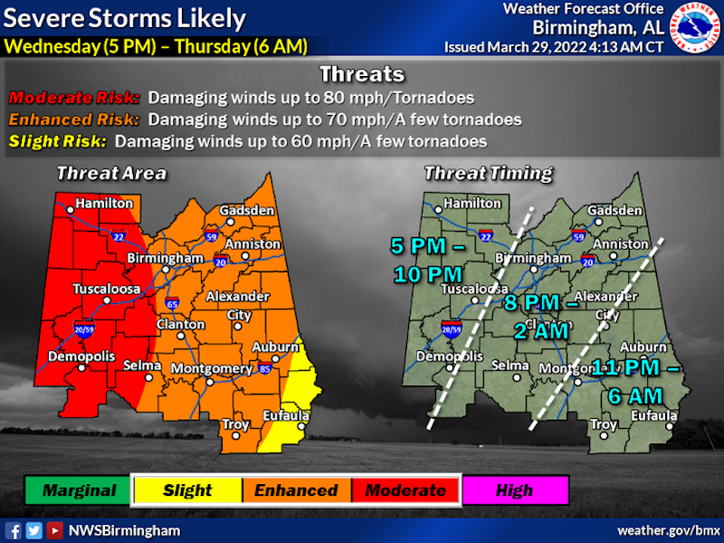
The National Weather Service has increased the risk of severe weather for Wednesday night, March 30.
With the latest update from the NWS, all of the state is included in an enhanced risk (3/5) and a large portion of the western side of the state included in a moderate risk (4/5).
A slim portion of Shelby County is included in the moderate risk area with the latest update and still more than 24 hours before the weather event occurs, while all of the county is included in the enhanced risk.
The main risk from the line of thunderstorms is expected to be damaging winds of up to 80 miles per hour in the moderate risk area and 70 miles per hour in the enhanced risk area.
There is also the threat of tornadoes spinning up along the line of storms throughout the event.
According to the National Weather Service out of Birmingham, straight-line wind gusts could reach 60-70 miles per hour, while gusts ahead of the storm could reach 40-50 miles per hour.
With those winds, fallen trees, power outages and property damages could all occur.
In addition to the threat for strong winds and tornadoes, 1-2 inches of rain are expected across Shelby County.
The line is expected to be in west-northwest Alabama from 5-10 p.m., while the impact locally will last from 8 p.m. until 2 a.m.
Follow Shelbycountyreporter.com for updates throughout the next two days.
More 280 Reporter


-
-

-
Polls
 Loading ...


