Be weather aware: Severe weather expected for Shelby County on Tuesday
Published 4:35 pm Monday, January 2, 2023
|
Getting your Trinity Audio player ready...
|
By ALEC ETHEREDGE | Managing Editor
A new year is here, but the same Alabama weather is upon is with warm temperatures and the threat of severe weather on the horizon.
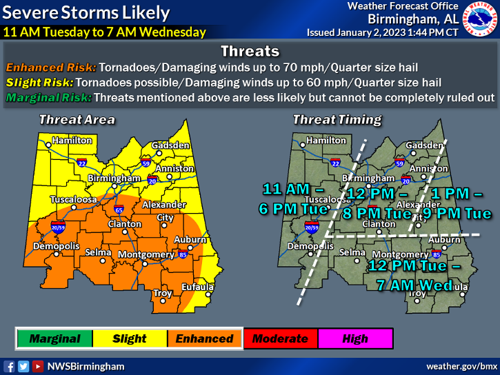
Amid a warm stretch, a front expected to make its way through Alabama on Tuesday, Jan. 2 will bring the threat of severe weather to the Shelby County area during the afternoon and evening hours.
The National Weather Service out of Birmingham has issued an enhanced risk for the majority of the county, which is a level three out of five on the threat meter. The enhanced risk includes all but the northeast corner of the county, which is under a slight (2/5) risk.
With the enhanced risk, there is a threat of tornadoes and damaging winds of up to 70 mph, while there is also the risk of quarter-size hail.
For those in the slight risk area, there is still the risk of a possible tornado with damaging winds up to 60 miles per hour and quarter-size hail.
In the enhanced risk area, there is the possibility of a strong EF2 tornado or greater.
Current forecasts show the possibility of rain throughout the morning, but the main threat for severe thunderstorms will come from noon-8 p.m. according to the NWS in Birmingham.
In addition to the storms, rainfall could possibly surpass 1 inch across the county.
Following the storms, the weather will cool off slightly in the coming week with highs in the 50s and low 60s and lows in the 30s and 40s.
The National Weather Service encourages everyone to be weather aware and to have plans in place should severe weather arise on Tuesday.
You can sign up for ShelbyALerts, which will send out a text and email should there be any tornado warnings, by visiting Shelbyal.com/252/Emergency-Management-Agency-EMA.
More 280 Reporter


SportsPlus
How to Watch the Braves vs. Phillies Game: Streaming & TV Channel Info for August 31
J.T. Realmuto and Orlando Arcia will look to continue their recent offensive production when the Philadelphia Phillies and…
Braves vs. Phillies: Betting Preview for August 31
Atlanta Braves (74-61) will take on the Philadelphia Phillies (79-56) at Citizens Bank Park on Saturday, August 31…
How to Watch MLB Baseball on Saturday, August 31: TV Channel, Live Streaming, Start Times
The MLB lineup today, which includes the Los Angeles Dodgers versus the Arizona Diamondbacks, should provide some fireworks.…
O’Dell, Fitzgerald combine for big offensive night, Oak Mountain improves to 2-0
There was no letdown for Oak Mountain senior quarterback Will O’Dell on Friday, Aug. 30, as he followed…
How to Watch the WNBA Today | August 31
Today’s WNBA schedule includes just one contest — the Connecticut Sun versus the Washington Mystics. The WNBA is…
-
-

-
Polls
 Loading ...


